
My M.S. project at the University of Connecticut tested what types of data are useful for characterizing habitat for saltmarsh sparrows. The presence of sparrows was predicted from remote-sensing data of spectral reflectance characteristics in the study plots, while nest presence was predicted using the proportion of high marsh that existed in the same study plots. Because areas of nesting activity are not well-identified by the same models that predict presence, a distribution model that describes only species presence would provide misleading information about where the most important areas for reproduction lie. Therefore, both presence and nesting maps are needed.
Additional information about the models used to build the maps are at:
Meiman, S., D. Civco, K. Holsinger, and C. S. Elphick. 2012. Comparing habitat models using ground-based and remote sensing data: Saltmarsh Sparrow presence versus nesting. Wetlands
32:725–736.
Additional information about the field tests of the maps are at:
Meiman, S., and C. S. Elphick. 2012. Evaluating habitat-association models for the
Saltmarsh Sparrow. Condor 114:856-864.
Maps
The maps identify areas of salt marsh in Connecticut where saltmarsh sparrows are most likely and least likely to be found, and most likely and least likely to nest. Map layers showing habitat for saltmarsh sparrow presence or nesting can be viewed as separate .kml files in Google Earth, or a single shapefile can be downloaded for use in ArcGIS.
Read the map metadata: Meiman_saltmarshmetadata2011.
Download saltmarsh sparrow presence habitat kml (zipped) for Google Earth: Saltmarsh Sparrow Presence Habitat-KML.
Download saltmarsh sparrow nesting habitat kml (zipped) for Google Earth: Saltmarsh Sparrow Nesting Habitat-KML.
Download map as a (zipped) shapefile: CT_Saltmarsh_Sparrow_habitat.
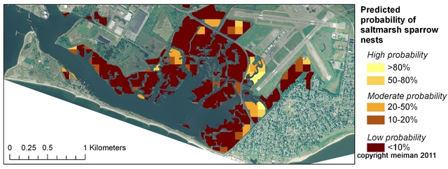
Map predictions
The probability of saltmarsh sparrow presence and nesting are presented for each 1 ha cell of a grid fitted to the extent of the salt marsh area of Connecticut. Each grid cell has a field predicting presence and a separate field predicting nesting. Predictions are scaled as a probability, where 0 indicates the lowest probability, and 100 indicates the highest probability. It is important to note that while each cell represented in the map predicts a probability of presence or nesting, it does not indicate whether a saltmarsh sparrow or a saltmarsh sparrow nest was found in the cell.
The maps cover the extent of salt marshes in Connecticut. Due to the irregular outlines of salt marshes, some grid cells are incomplete squares. Because predictions are based on patterns that occur at the 1-ha scale, cells <0.2 ha have been eliminated from the map. This map should not be used to delineate any legal extent of salt marsh area or any property boundaries.

Suggested citation: Meiman, S. 2011. Mapping saltmarsh sparrow habitat in Connecticut. Department of Ecology and Evolutionary Biology, University of Connecticut, Storrs, CT. On-line at: susanmeiman.org/home/saltmarsh-sparrow-habitat-maps, accessed xx/xx/20xx.
Additional resources on saltmarsh sparrows and salt marshes can be found through the Saltmarsh Habitat and Avian Research Program (SHARP) at http://www.tidalmarshbirds.org
and at
http://elphick.lab.uconn.edu/tidal-marsh-birds/.
(Note: The maps were previously available at hydrodictyon.eeb.uconn.edu/people/meiman, which is no longer available.)
Funding for this project was provided through the Department of Ecology and Evolutionary Biology at the University of Connecticut, the Connecticut Department of Environmental Protection, Office of Long Island Sound Programs, and the Connecticut Sea Grant College Project.
